 There is a wonderful thing here in Sydney called a Multi-pass. Most cities have a version of the multi-pass – a week- or day- or month-long ticket to use public transportation. Here, the pass allowed me to use trains, buses and ferries with impunity for seven days. I actually ended up purchasing more than one of these little miracle tickets because I was bound and determined to explore every neighborhood in Sydney. While I fell short of that goal, I still used the hell out of them.

At the Manly information kiosk, a nice woman explained the way out to the North Head and gave me a map (I didn’t have the heart to tell her it was going to be largely useless) and actually walked me outside to point out the correct bus stop. These Aussies seem to be highly attuned to my challenge. In the meantime, I sat down at a picnic table by Manly Beach and ate my tuna sandwich and chocolate covered caramels. On the way to the bus stop, I was distracted by a sign about protecting the Manly penguins. Penguins? Here? I thought they hung out on another continent called Antarctica. Turns out there are penguins here, specifically Little Blue Penguins, and their numbers are endangered. The penguins are the smallest species of penguin and they live on the southern coasts of New Zealand and Australia. In Manly, they make their home under the wharf, returning from their hunting at dusk, at which time people decide to snag them as pets – or people’s pets decide to snag them as food. A gregarious woman sitting on a nearby bench, not quite finished with her own sandwich, mentioned that just the other day a dog who was on a sailboat moored in the cove jumped off the boat and nabbed a little guy. The penguin was killed, of course, no word if it was eaten. (I didn’t want to ask – she seemed upset.) Since it wasn’t yet dusk, I didn’t get to see any of the flightless water fowl.

As detailed in my last entry, I have a tendency to get lost – even when there’s only one road and I’ve been instructed to go straight down said road until I reach a destination that is the only one on the map. I made it down to the North Head trail, which was really a road, which made me wonder if I was on the right path because it was described as a trail, and there was no trail, it was a bona fide two-lane road, so I started doubting if I was in the right place, because I’m a writer and editor and I damn well know what words mean, and this was not a trail, it was, in fact, a road. I was pretty sure that I was on the right path because the nice lady at the information kiosk had mentioned a car park area with a great view of Sydney, and I found that. I kept walking anyway, and reached the end loop where I did finally find a trail – a beautiful bush walk that led out to the cliffs that offered fabulous views of the Tasman Sea.

Then there was the question of making my way back and finding the trail (but was it really a trail because there wasn’t a trail here until I reached the end of a road …) to Shelly Beach, on the ocean side of the north peninsula. I wandered back and forth, stopped in at Q Station lobby a couple times to check my map; they gave me another map, and I still couldn’t find my way to Shelly Beach. So I took the bus back and walked The Corso to the beach, getting there just in time for lifeguard training. Not bad timing, and just the scenery I needed to see. I bought an (expensive) ice cream cone (funny how ice cream always makes sore feet feel better) and sat on the wall watching bronzed young men go through their paces. At the blast of a whistle, a whole line of them took off with some sort of hybrid surfboard, plunged into the waves, paddling furiously until they were just about out of site. I should point out that there were bronzed young women, as well, but I wasn’t interested in their tan lines.

My timing was better for the return voyage, and I secured a seat on the second level up front. The sun was s setting behind a light cloud cover, lighting up the sky behind the opera house and bridge. I sat to Susan and her companion Harry (a cousin from England, whom she referred to as “haitch”) and quizzed me on what I had seen so far. She pointed out the sunset sailing races, and asked me if I had heard of the Bridge to Beach Swim which starts at at Harbour Bridge and ends at Manly Beach. Her boyfriend (an “action man” as she identified him) does the 11 kilometer race every year.

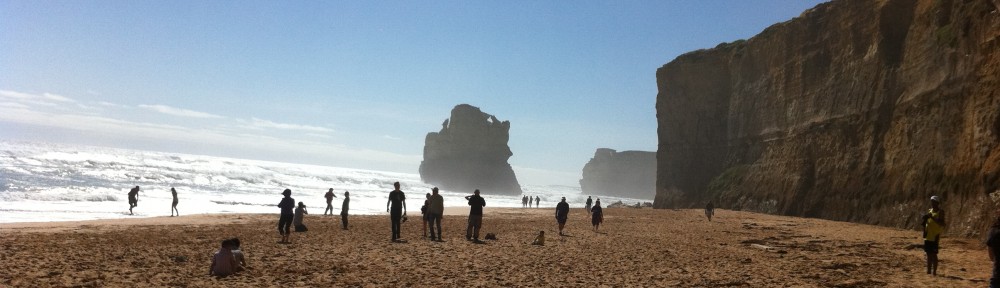
Which brings us to the matter of sharks. With some amount of pride, Susan declared that the harbour is full of sharks. She actually used the term “infested.” In fact, in 2009 race officials cancelled the swim due to the number of recent shark attacks in the area. As the Brisbane Times wrote, they feared the water could be too “bitey.” Although there are several shark attacks every year at Sydney beaches, most are not fatal. In fact, it’s more likely that a person will drown than get eaten by a shark. But. There is shark netting at many of the swimming beaches, including Manly Beach, maybe because the last death caused by a shark attack occurred there in 1963 while a young woman and her fiance played in about one metre of water. Most attacks are by bull sharks, who thrive in both fresh and salt water, and whose behavior is unpredictable and aggressive. (geez, do they drink and gamble, too?)
 |
| Manly Beach, site of the last fatal shark attack in Syndey Harbour |
After talk of sharks, Susan pointed out Kiribilli House, the official Sydney residence of Prime Minister Julia Gillard. It sits nearly straight across the harbor from the opera house and is easily seen from the ferry. The woman was especially pleased that the PM’s boyfriend is a former hairdresser, which is her profession.

 |
| View from The Gap toward North Head. |
Of course, there’s another gorgeous cliff walk out to lighthouses, past beaches and above the pounding surf. The first stop was at The Gap, though, a famous scenic point where in one direction there are gorgeous views of Sydney’s Central Business District and from the other, the sea. The Gap is also one of the top spots in Sydney for suicides (about 50 per year) and also for marriage proposals (no stats available) which cynics might say amount to the same thing. Seriously, there are signs all around The Gap with toll free numbers to call for help – before a person jumps.
What with all the cliffs and pounding surf, there are also lighthouses. Although the Macquarie Lighthouse has the distinction of being the first in Australia, the Hornby Lighthouse (lower head) with it’s slimming vertical red and white stripes is the one that’s more photogenic. A tragedy motivated the creation of the Hornby – actually two tragedies – the wreck of the Dunbar at South Head on August 20, 1857 and then the wreck of the Catherine Adamson on October 23, 1857 at North Head. Only one out of 122 people survived the Dunbar wreck, an Irishman named James Johnson who later became a lighthouse keeper at Newcastle. The Catherine Adamson passengers and crew fared little better; five survived (including the captain) along with two bulls and a horse. An enquiry blamed insufficient navigational aids and ordered the construction of the Hornby on the lower Southern Head.

Once again, I asked for directions before setting out, partly because I expected to be able to see the lighthouse from the cove where the ferry landed. But no. So I popped into a hotel, and asked the nice woman at the desk how to get to the lighthouse.

I walked across, let the ocean chase my feet, and took the footpath. A short walk brought me to yet another fabulous view of Sydney, and a little bit further on, I found the Hornby lighthouse. After retracing my steps, I was back at The Gap and debating whether or not to keep going to the Macquarie. Sure – I decided. I’ve got time. I can catch the ferry at 5 or 6.
